


[Note]
The route is basically a BennyJ and yardle agreed, because as yet no dealers Xitang ctrip articles on hand and no Songjiang Qingpu Jiashan the transportation plan, we can only map according to a Shanghai suburb part of the map, a version of the The electronic version of a very old map of Shanghai, as well as BennyJ figure borrowed from the one to select the route maps, Zhejiang Province. the return line is just a record, in fact, this line is the dealers of the positive solution.
[Related routes]
The original idea was yardle Huqingping line from the west, then south into the appropriate places Jiashan, but all in hand and on-line maps can not find this the ideal way to
[Later confirmed that this road does not exist], fear along the way to find this path may be more trouble,
But also in danger of being the case, this idea was quickly abandoned.
Later BennyJ compared a map of Jiashan, Shanghai suburbs and found that sediment from the Songjiang west highway through the steam and Jiashan maps should be available on the highways, and also found in Songjiang Sheshan Tianmashan line a newly built road can also be reached steaming lake, to compare the length of the road, identified the South Line, that is Qibao, Si Jing, Songjiang, Shihudang, steaming lake, small gate line.
Xitang had learned from the people, from the north via Shun Xitang to Qian's Bazaar ferry for over an hour can go to Kanazawa, in the past is Huqingping [ie 318 State Road], and this seems to be able to master them if prior information, Hu Qing Ping route is feasible, and probably the last line.
Return of Xitang to Xinzhuang Paragraph car, from the north gate to be too small Pu River, across the river is a river after the highway, turn left on the east, after a period of Zhufeng Road to Shen Shen Brick Lane, turn right by the road to the brick bridge, go straight through the Xinsong Road to Xinzhuang.
[Real line]
Leaves:
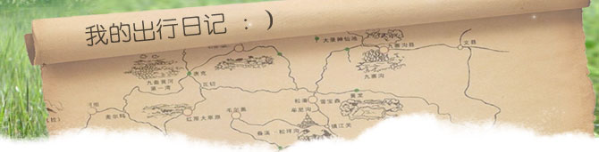
Big Cypress, Zhongshan North Road, West Sports Club Road, East Riverside Road, Baoshan Road, Henan Road, Beijing East Road, Tibet Road, Jinling Road, Changle Road, Huashan Road, Xujiahui, North Cao Xi, Cao Bao Road,
Qibao, Hu Song Highway, Si Jing, Songjiang, pine steam roads, shihudang, steaming lake, D grid, and to greet show bridge [Xitang]
Fan Hu:
Xitang, Ding-gate, too Urakawa along the river road, Zhufeng Road, Shen Lane, Shen brick road, brick bridge, Xinsong Road, Shanghai Minhang Road, North Cao Xi, Chao Jia Bang Road, Tin Ping Road, Xingguo Road, Huashan Road, Urumqi Road, Wanhangdu, Xin Zha Road, Wuzhen Road, Tian Mu Road, Baoshan Road, East Riverside Road, West Sports Club Road, Zhongshan North Road, Big Cypress
[Details]
Shanghai Pine Jiuting on the road, and the pine steamed Dongjing port on the road, small steamed shihudang are without a township, careless passed do not know, is not suitable as a checkpoint.
Song steamed steamed Highway approaching lake where there is a north-south slipped far south from here is the steaming lake, and steam sediment sink side of the road signs to Yu, but Yu Department in Zhejiang province is to look at not on the map to the only Dong-Yu Nan Yu Yu, North West, four names, in fact, we just gone through Yu north.
[More]
First to say that our line, the Shanghai within Needless to say, from that part of Songjiang Road, Xujiahui to it is really very very depressed, though not very smooth surface, this matter whether, and detestable is the net is the mud, [since October 5 night, rain, yellow sand, but otherwise the sky is afraid of it, compared to the lesser of two evils, think, or mud are not very uncomfortable] speed somewhat faster than the ability to walk on the chaos that would go visit the mud splashing,
The results of this section of track took us nearly three hours; Songjiang to Zhengdian the road like some, but the road is very narrow, they are more cars and going is not very comfortable; Zhengdian highway along the river over a period of [there is only one lane width concrete surface can be regarded as highway bar] is also OK, but the one road into the territory of Zhejiang becomes increasingly worse, remitted from the Yu Ding-gate is the most desperate for some distance, the road is extremely bumpy, this road on the map even has the nerve to use the red line outlined is somewhat puzzling, BennyJ once-suspicion is not lost. in part because of rivers and lakes located in the bar, from the Songjiang west,
The height of the bridge is getting frightening, and on the physical consumption are also high. This line is useless if you can not, then at least it is not suitable for bicycles.
Fan Hu route from the small gate to the road Taipu River is about 3-4 kilometers look like it,
Guo Tai Po River posterior is very good to go too the north bank of the river Po is a two-lane highway concrete pavement width, located in rural areas, very few cars on the road, south of Taipu River, north of the land, nice scenery; Shen brick road traffic well, not many cars, and the road side are mostly fields, unlike the Shanghai Song is almost always along the road like that town, brick bridge east to the Xinzhuang it seems to me is a new repair, and it is a good road cars. because the ratio The line sinks Yu Zhengdian less walking a few detours and the length of this road should also be shorter than our line a lot, and then taking into account the road conditions and scenery along the road, this road should be the most suitable for bicycles.
From Kanazawa ferry to Jiashan Qian Austin should be the last line, but the Huqingping on cars are likely to be more and more afraid of the route is not very quiet, can be considered as a return route.
Author: yardle